Gruner's ADAM service
Acquisition, Diagnostics, Analysis and Monitoring
With the latest in 3D laser scanning and photogrammetry technology, it is now easier than ever to survey and model with high accuracy and precise location data. Indeed the latest technologies allows us to gather significantly larger amounts of data far more quickly, far more accurately, cost-efficiently than traditional methods. Indeed we can safely survey in situations and locations which previously too dangerous to survey with conventional methods.
Acquisition
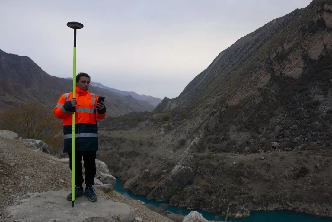
Using precision tripod mounted laser scanners, any building or structure can be mapped to mm accuracies. Using Drone mounted laser scanners, any structure can be mapped to cm accuracies. With a laser that measures millions of points, 3D Scan data can then be integrated with other information into Autodesk software and other CAD, GIS and web platforms where it can be used to make informed decisions. The data can also be integrated into the engineering design workflow to identify design conflicts and to test design concepts.
We have scanned numerous structures of all types both man-made and natural formations alike and all this from a safe distance. The data that we collect can be used by our experts and engineers to support the decision-making process throughout project life cycles in nearly every engineering sector including buildings, transportation, infrastructure, railways, aviation, energy, utilities and oil and gas.
The applications and use cases are extremely diverse and still developing, as-built data can be collected for nearly any structure, including piping, single vessels and entire plants, as well as topographies, including single and multi-lane roads, intersections and bridges.
Laser scanning, Lidar and photogrammetry surveys offers several advantages over traditional survey methods:
- Proven lower cost “as-built” and topographic surveys, due to faster data collection and shorter project cycle times
- Reduction or elimination of costly return visits to the site
- More accurate, complete as-builts for retrofit and design, enabling offsite fabrication and less construction rework caused by interferences and fit-up problems
- Reduced facility downtime, as a result of the unobtrusive scanning procedure
- Scan data can be delivered via a complementary viewer such as SketchFab, as 2D or 3D CAD, or in a variety of laser scan formats that can be manipulated by the client.
We deliver the building information modelling (BIM) data you need to support smart decision-making regarding your constructions. At Gruner we use 3D scanning technology to create exact digital models to help our architects, engineers and designers visualize form and function to predict costs and make any necessary changes in advance of the construction. Making decisions earlier in the process to avoid costly mistakes and ensure the construction of a well-built, cost-effective, energy-efficient structure.
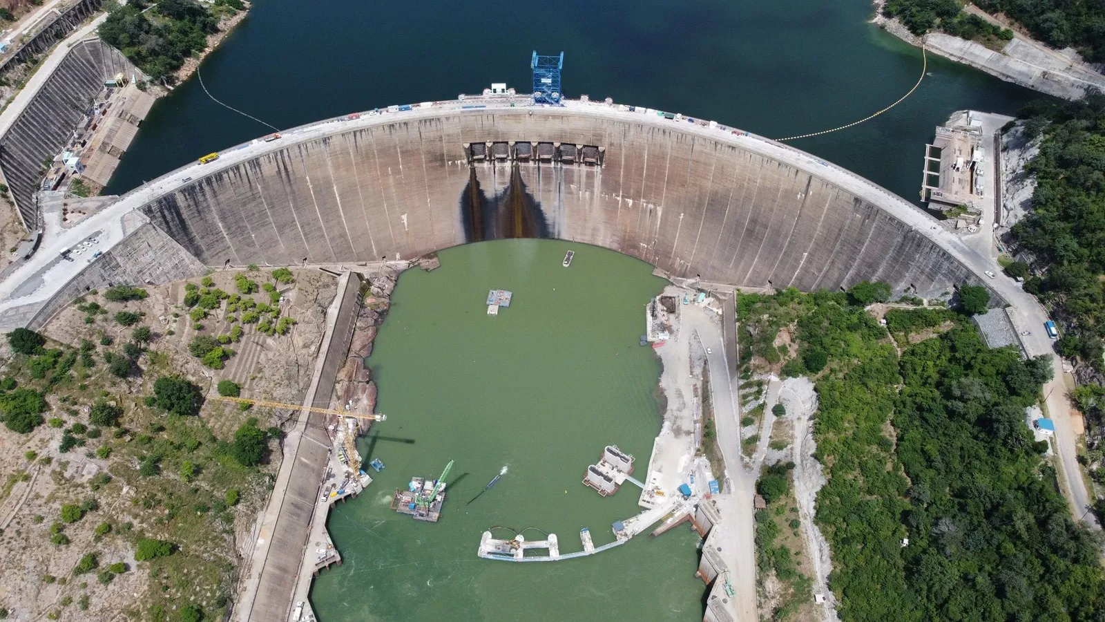
We are developing our survey and inspection services in close cooperation with our dam and hydropower engineering requirements. The data we can capture on dam and hydropower projects includes bathymetry, topography and 3d scans for rehabilitation projects. This data can be used for everything starting with feasibility studies, rehabilitation design using BIM, hydraulic modelling and of course, dam safety inspections. Our strength is that as experts in this domain, we know exactly what data we need. Now we can go out and capture it.
Our focus :
Aerial Inspections: Do you need to assess the current status of a bridge, a tunnel, a building or a dam, or any normally inaccessible or difficult to access places? With the use of drones we can conduct an inspection based exactly according to your needs and all of this not just in 2D but also inside of fully interactive 3D models.
Refurbishment, renovation, rehabiliation and modernisation projects: Do you need to renovate a building? Do you know have As-built plans that you can use as a basis for your rehabilitation project.
Smart City solutions: The Smart City concept is the future of urban development. 3D scanning is an irreplaceable method of data gathering as it produces highly accurate 3D models. A 3D scan of a city or any surface area can be used for an urban planning, analyses and with additional statistical data, simulate noise zones or flood risk.
Real estate and residential development projects: What are the benefits of 3D models in real-estate projects? With the detailed scan of whole environment, we can create authentic virtual model of the real place. This helps in communications such as public consultation and also in the decision making process, using a digital twin you won’t have to explain the advantages and disadvantages of a particular layout, you can show it.
Processing and Analysis
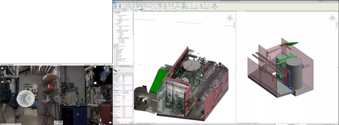
We use high-definition 3D laser scanning and photogrammetry to create BIM models to serve as the basis for refurbishment, renovation and rehabilitation projects. It is the fastest and most accurate process to create a BIM model with “As Built” data of the current state of the existing structures. Gruner’s Scan2BIM services in this respect include :
- 3D scanning of the interior and exterior of all types of structures.
- Processing and check the quality and accuracy of the scans.
- Create the point cloud files
- Import the point clouds into Autodesk Revit
- Create BIM model from the point clouds
- Store and maintain the BIM model and scans for future work on the structure.
Monitoring
Digital twins and photomeshs – and the monitoring of diverse structures
Scan2BIM data is only the beginning of the process, on the basis of our 3D scanning services, we can produce highly accurate 3D models with integrated data for the simulation of data, (see our Early Stage Design capabilities). These intelligent models allow you to filter, select or search for elements of your installation.
Digital twins which are more correctly termed photomeshs started out as virtualized representations of physical objects and installations. They are often still used as that but with the advances in cloud-based data processing, artificial intelligence, machine learning and especially with the connection of more and more objects to the internet i.e. the so-called Internet of Things (IoT).
Digital twins are now used as real-time simulations, a virtual environment if you will with all the characteristics to reflect the real-life physical object to whatever action or a reaction. The applications of digital twins are just beginning to be discovered but stretch from training to Emergency response planning.
The era of Big data and the internet of things has enabled a lot of innovation in the infrastructure monitoring sector. As the BIM design methodology is taking hold around the world so too is the Internet of Thing (IoT) – sensors of all types can now be connected to the internet and telemetry transferred in near-real time. This will provide a leap forward with regards to facility management as projects are developed using a BIM model so can they be managed using a BIM model. We therefore have for objective to connect BIM models of the facilities we design to the constructed installations thereby permitting operations, maintenance and logistics to be optimized in terms of quality, efficiency and most importantly safety.
Other benefits of digital twins include such things as advanced planning, imagine being able to train your staff to operate the powerplant in a virtual reality environment before it has ever been built. They’re would be no confusion at the start no searching for materials or locations, all trained personnel would know where to find them, they would just have to retrace their virtual steps but this time in reality.